 wbcap
wbcap
Samsi College
Estd. 1968
Affiliated to University of Gour Banga
NAAC Accredited With "B" Grade (2nd Cycle)
About
Department of Geography


Overview
The Department of Geography at our college was established on March 23, 2009. Since its inception, the department has been committed to providing quality education in geographical sciences with a focus on developing analytical thinking and practical skills among students. The department offers a Bachelor's Degree in Geography program following the Choice-based credit system (CBCS) as prescribed by the University of Gour Banga curriculum, allowing students flexibility in selecting courses according to their interests and career aspirations. Since the 2023-2024 academic session, the National Education Policy (NEP) has been implemented, bringing comprehensive reforms and enhanced learning opportunities to the curriculum. The department is staffed with dedicated and experienced faculty members who bring diverse expertise to the teaching-learning process: Dr. Rameswar Mukherjee (Assistant Professor & Head), Md. Aminul Islam (SACT-I), Md. Mursedul Hasan (SACT-I), and Md. Aminul Hoque (SACT-I).
Vision
To cultivate geographically literate and environmentally conscious citizens equipped with spatial thinking skills who can make significant contributions to nation-building and sustainable development by applying their knowledge of geographic processes and spatial analysis to the complex interactions between human societies and the environment.
Mission
- To provide high-quality education in geography that balances theoretical knowledge with practical skills and field experience.
- To foster critical thinking and research skills among students, encouraging them to explore geographical phenomena and their implications for society and the environment.
- To equip students with advanced technological skills in Geographic Information Systems (GIS), remote sensing, and cartography, enhancing their employability in the modern job market.
- To promote an understanding of local and global environmental issues, instilling a sense of environmental consciousness and commitment to sustainable development.
- To encourage students to apply geographical knowledge to real-world problems, particularly those facing rural and underprivileged communities in the region.
- To develop students' analytical and communication skills, enabling them to effectively convey complex geographical information to diverse audiences.
- To nurture a sense of social responsibility among students, encouraging them to use their geographical knowledge for the betterment of society and nation-building.
- To focus on the effective and efficient training of students, enabling them to achieve their aspirations in the present-day job market and beyond.
Departmental Strengths
Modern Facilities
The department is equipped with modern teaching aids, a specialized geography laboratory, field equipment, and digital resources that enhance the learning experience.
Field Studies and Practical Training
We place strong emphasis on field-based learning, organizing regular field trips to diverse geographical locations that allow students to observe and analyze geographical phenomena firsthand.
Research Orientation
The department encourages undergraduate research projects that address local geographical issues, providing students with early exposure to research methodologies and analytical thinking.
Career Preparation
Beyond academic excellence, we prepare students for diverse career paths in urban planning, environmental management, GIS applications, disaster management, and climate change adaptation through specialized workshops and career guidance sessions.
Community Engagement
The department actively participates in community outreach programs focusing on environmental awareness, disaster preparedness, and sustainable resource management in nearby communities.
Future Directions
As we move forward, the Department of Geography aims to expand its academic offerings, strengthen research capabilities, forge more industry partnerships, and enhance infrastructure to provide cutting-edge geographical education that meets global standards while addressing local needs.
| Name of the Department | Year of Establishment | Names of the Programmes/ Courses offered | Names of Interdisciplinary courses and the departments/ units involved | Annual/ Semester/ Choice based credit system (Programme wise) | Seat Intake Capacity | Faculties |
|---|---|---|---|---|---|---|
| Geography | 23.03.2009 | UG | Environmental Science |
Choice-based credit system as per the University of Gour Banga curriculum National Education Policy (NEP)-2020 as per the University of Gour Banga curriculum |
General-24 SC-10 ST-03 OBC-A-04 OBC-B-03 TOTAL-44 |
1. Dr Rameswar Mukherjee, Assistant Professor & Head 2. Md. Aminul Islam, SACT-I 3. Md. Mursedul Hasan, SACT-I 4. Md. Aminul Hoque, SACT-I |
Courses & Syllabus
Dr. Rameswar Mukherjee
MA, PhD, CCSM
Assistant Professor & Head Department of Geography
Specialization : Remote Sensing & GIS, Fluvial Geomorphology , Quaternary Geomorphology, Application Statistical Methods in Geography, Cartographic Techniques
View Details
Md. Mursedul Hasan
M.A., Net qualified, M.Ed.
SACT- I
Specialization : 1. Advanced Geomorphology 2. Population Geography 3. Geography of India 4. Economic Geography 5. Social And cultural Geography
View Details
Md. Aminul Hoque
M.A, SET qualified
SACT- I
Specialization : Geotectonic, Climatology, Oceanography, Geomorphology
View Details
- CLASS ROUTINE GEOGRAPHY 2024-2025
- CLASS ROUTINE GEOGRAPHY GENERAL 2023-2024
- CLASS ROUTINE GEOGRAPHY HONOURS 2023-2024
- CLASS ROUTINE OF GEOGRAPHY HONOURS 2022-2023
- BEHAVIOURAL GEOGRAPHY IN BENGALI-DR. RAMESWAR MUKHERJEE
- Concept of Space in Geography-DR. RAMESWAR MUKHERJEE
- BASICS OF REMOTE SENSING-DR. RAMESWAR MUKHERJEE
- Human-Nature interaction-Challenges and conflict-Dr Rameswar Mukherjee
- Chisqare test-Dr Rameswar Mukherjee
- LIFE TABLE PREPARATION_Dr. Rameswar Mukherjee
- ভূগোলে মাত্রিক বিপ্লব -Quantitative Revolution in Geography-Dr. Rameswar Mukherjee
- CLIMATOLOGY-NSOU
- GEOGRAPHICAL THOUGHT-NSOU
- GEOTECTONICS & GEOMORPHOLOGY
- POPULATION GEOGRAPHY, NSOU
- PRACTIAL GEOGRAPHY PART -I,NSOU
- PRACTICAL GEOGRAPHY PART -III,NSOU
- PRACTICAL GEOGRAPHY PART -II,NSOU
- RESOURCE GEOGRAPHY, NSOU
- SETTLEMENT GEOGRAPHY,NSOU
- SOIL & BIOGEOGRAPHY, NSOU
- MEASUREMENT OF BIODIVERSITY_UPDATED
- REDLIST INDEX-DR.RAMESWAR MUKHERJEE
- Ecological_Footprint-Rameswar Mukherjee
- GLOBAL WARMING-DR. RAMESWAR MUKHERJEE
- CLIMATE CHANGE ADAPTATION-Rameswar Mukherjee
- origin of indian monsoon bengali-DR. RAMESWAR MUKHERJEE
- CARBON TRADING-DR. RAMESWAR MUKHERJEE
- CLEAN DEVELOPMENT MECHANISM_DR. RAMESWAR MUKHERJEE
- Conference of the Parties (COP)2025-DR. RAMESWAR MUKHERJEE
- Lecture Note-GEOGRAPHICAL THOUGHT by Md Mursedul Hasan
- Lecture Notes-GEOTECTONICS & GEOMORPHPOLGY by Md Mursedul Hasan
- Lecture Note of Agriculture, Prepared By Md .Aminul Hoque
- Lecture Note of Bio-Diversity, Prepared By Md .Aminul Hoque
- Lecture Note of Climate Change, Prepared By Md .Aminul Hoque
- Lecture Note of Davis Concepts of Cycle, Prepared By Md .Aminul Hoque
- Lecture Note of Earth Movement, Prepared By Md .Aminul Hoque
- Lecture Note of Economic Activities, Prepared By Md .Aminul Hoque
- Lecture Note of Global Warming, Prepared By Md .Aminul Hoque
- Lecture Note of Natural Hazard & Disaster , Prepared By Md .Aminul Hoque
- Lecture Note of Plate Tectonic Prepared By Md .Aminul Hoque
- Lecture Note of Rural Development Prepared By Md .Aminul Hoque
- Study Material Aminul Islam
- 6th SEMESTER GEOGRAPHY HONS QUESTIONS_2025
- B.A. PART I GEOGRAPHY HONOURS THEORY QUESTION PAPERS 2011-2018
- B.A. PART II GEOGRAPHY HONOURS THEORY QUESTION PAPERS 2016-2018
- B.A. PART II GEOGRAPHY PRACTICAL QUESTION PAPER 2011-2018
- B.A. PART III GEOGRAPHY HONOURS THEORY QUESTION PAPERS 2016-18
- B.A. PART-III GEOGRAPHY PRACTICAL QUESTION PAPER 2015-2018
- 6th SEMESTER 2022 ALL QUESTION PAPERS
- B.A PART I GEN 2020
- B.A PART I HONS (OLD) 2020
- B.A PART II GEN 2020
- B.A PART III DESCRIPTIVE QUESTION 2021
- B.A PART III PRACTICAL QUESTION 2021
- Practical Questions Year 2018
- Practical Questions Year 2019
- Practical Questions Year 2022
- Practical Questions Year 2023
- Practical Questions Year 2024
- Theory Questions 2017
- Theory Questions Year 2018
- Theory Questions Year 2019
- Theory Questions Year 2022
- Theory Questions Year 2023
- Theory Questions Year 2024
- Monthly Test Question
- Monthly Test Question Aminul Hoque
- Monthly Test Question
Application of GIS based AHP for FLOOD RISK Assessment_Rameswar Mukherjee
Bank erosion and Accretion dynamics_Rameswar Mukherjee
Planform Dynamics_Ramganga River_Rameswar Mukherjee
|
Publications Profile Name of the Teacher & Designation: Dr. Rameswar Mukherjee, Assistant Professor & Head, Department of Geography |
|
Book Published |
|
01 (Accepted for Publication from ICSSR) |
|
Article Published in Journal/Chapter in Edited Book |
|
2025
2024
2023 i. Mukherjee, R. and Deb, P. (2023) Application of GIS-based Analytical Hierarchy Process for assessment and mapping of Flood Risk Zone in the Lower Ramganga River Basin, Western Gangetic Plain, India. Environment, Development and Sustainability. https://doi.org/10.1007/s10668-023-02957-z. Springer. E-ISSN 1573-2975 2022. i. Deb, P., & Mukherjee, R. (2022). Pattern of Regional Disparities in the Level of Household Deprivation among the Scheduled Tribes of Eastern India: A District-level Analysis. Journal of Asian and African Studies, 00219096221106097. Online ISSN: 1745-2538 ii. Mukherjee, R. (2022). Quantitative Assessment of Channel Planform Dynamics and Meander Bend Evolution of the Ramganga River, Ganga Basin, India. In Shit, P.K., Bera, B., Ghosh, S., and Bhunia, G.S. (Eds.) Drainage Basin Dynamics (pp. 89-113). Springer, Cham. E-ISBN 978-3-030-79634-1 iii. Deb, P., & Mukherjee, R. (2022). Household Vulnerability of Tribal People to Climate Change in the Part of Dooars Region, West Bengal, India. In Mishra, M., Singh, R.B., de Lucena, A. & Chatterjee, S. (eds.) Regional Development Planning and Practice (pp. 385-408). Springer, Singapore. ISBN 978-981-16-5681-1 (eBook). iv. Mukherjee, R. (2022). Palaeohydrologic Estimates of Flood Discharge of Lower Ramganga River Catchment of Ganga Basin, India, Using Slackwater Deposits. In: Pradhan, B., Shit, P.K., Bhunia, G.S., Adhikary, P.P., Pourghasemi, H.R. (eds) Spatial Modelling of Flood Risk and Flood Hazards. GIScience and Geo-environmental Modelling. Springer, Cham. ISBN 978-3-030-94544-2 (eBook) https://doi.org/10.1007/978-3-030-94544-2_3 v. Deb, P., Mukherjee, R., Assessing stages of development with Household Quality of Life Index: A Cross-Sectional study among the social groups of Rural West Bengal, India. Indian Journal of Spatial Science, 13 (1):pp.65-74. E-ISSN 2249 - 4316 2019 i. Mukherjee, R., Ram Bilas, 2019. Flood frequency analysis of Ramganga River Basin in Western Gangetic Plain, India, National Geographical Journal of India. 65 (3): pp.286-299. 2017 i. Mukherjee, R., Ram Bilas, Biswas, S. S., and Pal, R., 2017. Bank erosion and accretion dynamics explored by GIS techniques in lower Ramganga river, Uttar Pradesh, India. Spatial Information Research, 25(1): pp.23-38 ii. Mukherjee, R., 2017. Spatial pattern of meander bend instability and mechanisms of meander bend change in the Ramganga River, Western Gangetic Plain, India. Research Today: An International Peer Reviewed and Refereed research Journal of Humanities and Social Sciences, VIII (1): pp.304-321 iii. Mukherjee, R., 2017. Impact of flood on socio-economic life of the people: A case study on Katamuni Village, Harischandrapur-II Block, Malda, West Bengal. Annals of Multi-disciplinary Research. VII (2): pp. 501-512. 2016 i. Mukherjee, R., Ram Bilas, 2016. Topographic characteristics of Ramganga River Basin: Digital Elevation Model and GIS Based Study, National Geographical Journal of India.62 (3): pp. 201-216. ii. Paul, K., Sharma, D., Mukherjee, R., Sengupta, R., and Tamang, K. L., 2016. Demographic characteristics and changing land use pattern in Gangtok, Sikkim (1975-2011). International Journal of Geomatics and Geosciences, 6 (4): pp.1769-1780. 2015 i. Deb, Pamela, and Mukherjee, R. 2015. Sustainable Tourism in India: Challenges and Opportunities. Salesian Journal of Humanities and Social Science. 6(1): pp.11-22 ii. Mukherjee, R., and Ram Bilas, 2015. River Channel Dynamics: A Review. Indian Journal of Landscape Systems and Ecological Studies, 38 (1):pp.48-60. iii. Mukherjee, R., and Ram Bilas 2015. Evaluation of Ground Water Resource of Son River Basin: Using Remote Sensing and GIS Techniques. In Siddiqui, Farasat Ali (ed.) Population Dynamism and Resource Utilization: Geo-Informatics and Resource Dynamics. Academic Publication, New Delhi:pp. 204-212.ISBN: 978-93-83931-18-7 2014 i. Mukherjee, R., Ram Bilas, 2014. Analysis of relief through morphometric attributes: A Case study in part of Son river basin. National Geographical Journal of India. 60(4):pp.407-422. ii. Mukherjee, R., and Sharama, V., K., 2014. Natural Disaster Management for promoting Sustainable Development in India. Multidisciplinary Journal of Contemporary Research, 1(4):pp.73-80. iii. Deb, P., and Mukherjee, R., 2014. Globalisation-rural poverty nexus in India. Multidisciplinary Journal of Contemporary Research, 1(4):pp.11-18. iv. Mukherjee, R., 2014. A Quantitative Analysis of the Drainage Characteristics of Part of the Son River Basin. Geo-Analysist, 4 (1): pp. 52-70. 2013 i. Mukherjee, R., and Deb, P., 2013. Integrated Remote Sensing and GIS based Hydrogeomorphological study for groundwater potential evaluation-A case study in part of Vindhyan Upland. Journal of Geo-Environment Observer, 2 (2): pp.35-44. 2012 i. Mukherjee, R., 2012. Food Security in Rural India. Geo-Analysist, 2 (2): pp.33-39 ii. Mukherjee, R., 2012. Remote Sensing and GIS based regional geomorphological mapping: a case study of a part of the Son river basin. Journal of Geo-environment Observer. 1(2):pp.73-78. |
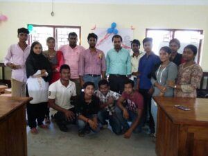
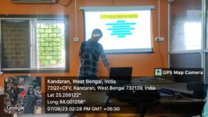
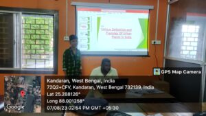
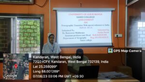
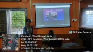
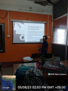
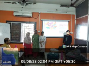
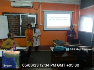
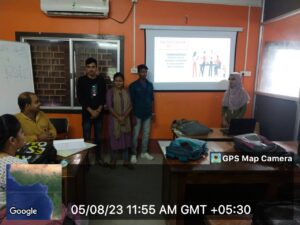
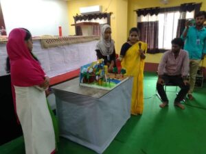
Student Seminar (2nd Semester Geography Honours), Organized on 07/08/2023
Group Discussion (4th Semester Geography Honours)
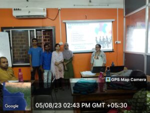
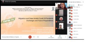
National Webinar on "Migration and State Amidst COVID-19 Pandemic: Challenges and Future Preparedness" organised by Dept. of Geography, Samsi College on 25th July 2020


|
Sl No |
Name of the students |
Year of Passing |
Job |
Date of Joining |
|
1 |
Dipa Sarkar |
2014 |
Assistance Prof. Birosthali Teachers Training College |
01/04/2022 |
|
2 |
Sk asrabuddin |
2014 |
Assistance Prof. Maharaja College of Education |
26/03/2021 |
|
3 |
Md Najibul Hoque |
2013 |
Assistance Prof. Universal College of Education |
15/07/2022 |
|
4 |
Rajia Sultana |
2014 |
Assistance Teacher of Naikanda primary School |
19/02/2021 |
|
5 |
Sabina Parvin |
2014 |
GNM Nursing Harishchandrapur Hospital |
16/03/2018 |
|
6 |
Sanchyeta Hembrom |
2014 |
GNM Nursing |
4/7/2021 |
|
7 |
Debobrata Das |
2014 |
West Bengal Police |
5/2/2022 |
|
8 |
Md Ismail |
|
West Bengal Police |
2/3/2023 |
STUDENTS ACHIEVEMENTS


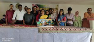
[caption id="attachment_1733" align="alignnone" width="355"]
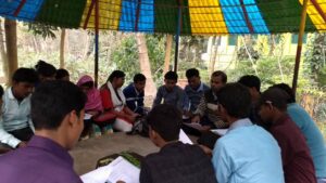 Pre-field Discussion[/caption]
[caption id="attachment_1735" align="alignnone" width="300"]
Pre-field Discussion[/caption]
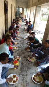
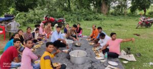
[caption id="attachment_1735" align="alignnone" width="300"]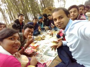 Lunchtime during a field excursion[/caption]
[caption id="attachment_1736" align="alignnone" width="300"]
Lunchtime during a field excursion[/caption]
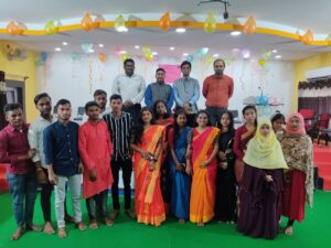
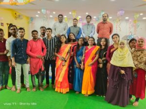
[caption id="attachment_1736" align="alignnone" width="300"]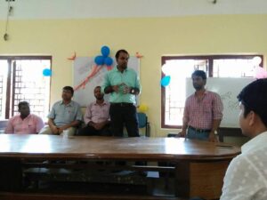 Teachers' Day Celebration, 5th September 2018[/caption]
[caption id="attachment_1730" align="alignnone" width="328"]
Teachers' Day Celebration, 5th September 2018[/caption]
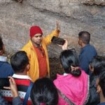
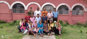
[caption id="attachment_1730" align="alignnone" width="328"]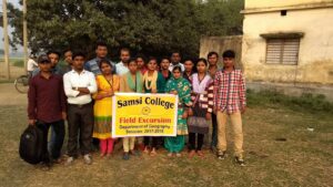 Field Excursion at flood-affected Katamuni Village, Malda[/caption]
[caption id="attachment_1729" align="alignnone" width="300"]
Field Excursion at flood-affected Katamuni Village, Malda[/caption]
[caption id="attachment_1729" align="alignnone" width="300"]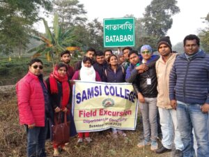 Field Excursion at Batabari Tea Garden, Jalpaiguri District[/caption]
[caption id="attachment_1408" align="alignnone" width="248"]
Field Excursion at Batabari Tea Garden, Jalpaiguri District[/caption]
[caption id="attachment_1408" align="alignnone" width="248"]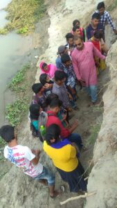 Understanding the processes of bank erosion at Manikchak, Malda[/caption]
[caption id="attachment_1670" align="alignnone" width="342"]
Understanding the processes of bank erosion at Manikchak, Malda[/caption]
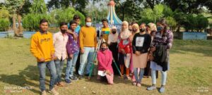
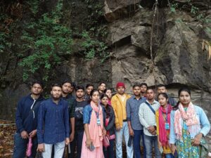
[caption id="attachment_1670" align="alignnone" width="342"]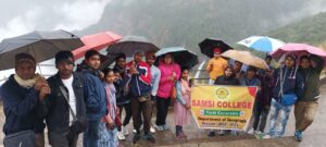 Field Excursion, Cherrajunji, Meghalaya, 2023[/caption]
[caption id="attachment_1731" align="alignnone" width="300"]
Field Excursion, Cherrajunji, Meghalaya, 2023[/caption]
[caption id="attachment_1731" align="alignnone" width="300"]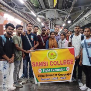 at Guwahati Station, 2023[/caption]